| 3.1 (158.9) | Town of Cartago. In the latter part of the last century, Cartago was the port for the off-loading of silver-lead bullion from the Cerro Gordo Mine on the crest of the Inyo Range. Bullion was transported by steamer across Owens Lake, which then was about 30 feet deep. This activity ceased in 1879, when the mines were shut down. For a detailed account of these days in the Owens Valley, and for other historic details, you are referred to Deepest Valley (Smith, 1978). |
| | In 1913, when the Owens River was diverted into the Los Angeles aqueduct, Owens Lake began to diminish in depth and size. The pre-1913 lake covered about 100 square miles. Pleistocene Owens Lake was twice as large and more than 200 feet deep. |
| 2.2 (191.1) | Saltworks on right. A number of salt works have operated in the past on the shores of Owens Lake. Sodium carbonate (soda ash) and some boron has been produced from brines and from the lake flats. |
| 0.3 (191.4) | Railroad crossing. |
| 8.5 (199.9) | Abandoned saltworks at 3:00. |
| 3.5 (203.4) | At 3:00 is a set of "bath tub rings" formed by the rapid recession of Owens Lake following the diversion of Owens River to the Los Angeles aqueduct in 1913. |
| 1.9 (205.3) | Alabama Hills and Diaz Lake in view to the left and ahead. Prominent peak at 9:15 is Lone Pine Peak (12,944'). |
| | From the south end of the Alabama Hills north to Big Pine, more than 50 miles, we are in the area very directly affected by the 1872 Owens Valley earthquake. Surface breakage and very large scarps were produced over this distance. It has been called California's largest earthquake, perhaps more than 8.3 magnitude. Twenty-nine people were killed. The main zone of faulting was along the east side of the Alabama Hills. Diaz Lake lies in a graben between the Alabama Hills and a small fault east of the lake. The graben was produced suddenly at the time of the 1872 earthquake. |
| | Figure 6
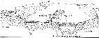 illustrates the relation of the Alabama Hills to the Owens Valley to the east and the Sierra Nevada block to the west. It is difficult to realize when standing on the east side of the Alabama Hills that the depth to bedrock (about 9,000') very closely rivals the elevation difference between the surface of the Owens Valley and Mt. Whitney (14,495'). illustrates the relation of the Alabama Hills to the Owens Valley to the east and the Sierra Nevada block to the west. It is difficult to realize when standing on the east side of the Alabama Hills that the depth to bedrock (about 9,000') very closely rivals the elevation difference between the surface of the Owens Valley and Mt. Whitney (14,495'). |
| | The Alabama Hills are a block of Triassic and Jurassic metavolcanics (mainly on the east side) intruded by later Mesozoic granitics. On our return to Los Angeles on the fourth day, we will make a side trip through the Alabama Hills to view the movie and TV scenery you will immediately recognize. |
| | As we approach Lone Pine, we will make a brief stop (not numbered) to view the high peaks of the Sierra, including Mt. Whitney. |
| 2.1 (207.4) | Death Valley Road to right. |
| 1.9 (209.3) | Whitney Portal Road to left. |
| 0.4 (209.7) | Just north of Town Park and baseball diamond at north end of Lone Pine, look at 9:00 across open field to view the scarp cutting the base of an alluvial fan at the mouth of the small canyon. This is an 1872 earthquake scarp. |
| 0.5 (210.2) | Grave of the 1872 earthquake victims on the left. From this point north for about 3.5 miles, note the fault scarp on the left. Nearest Lone Pine it is close to the road and only about 3 feet high; it will gradually increase in size and depart northwestwardly from the highway until it turns toward the highway again and intersects our path at the end of this stretch. |
| | Before we reach the scarp, the high granitic peak on the skyline of the Inyo Range at 3:00 is New York Butte (10,668'). About five miles north, and underlain by late Paleozoic carbonates is Keynot Peak (11,101'). |
| 3.4 (213.6) | Here we climb up across the 1872 fault scarp. |
| 3.5 (217.1) | Los Angeles aqueduct. |