| 1.5 (55.9) | San Andreas road cut. Approaching the cut, we can see a small 5-10' scarp along the south side of the ridge. This is the scarp produced at the time of the 1857 Fort Tejon earthquake. The large roadcut exposes highly folded Pliocene Anaverde Formation
(Plate 1)
 comprising a slice of bedrock caught between two segments of the San Andreas fault. comprising a slice of bedrock caught between two segments of the San Andreas fault. |
| | After passing through the San Andreas cut, you can breathe a sigh of relief, as you are now safely on the American Plate and need have no fear (except near the Hilton Creek fault on the Second Day) until late on the Fourth Day of the trip. |
| | From here to north of the Kern County Line, we will be passing across the featureless Antelope Valley, an alluvial basin with as much as 5,000 feet of unconsolidated fill in places. |
| 18.9 (74.8) | Kern County Line. The Rosamond Hills are dead ahead. |
| 3.5 (78.3) | Crossing the Rosamond fault, marking the south boundary of the Rosamond Hills. The ridge is principally Mesozoic granitics overlain by the middle Tertiary Tropico Group, composed of volcanic tuffs and flows and sedimentary rocks. Farther to the east at Boron, the Tropico Group contains very rich deposits of borate minerals. |
| | The following is taken, with thanks, from Glazner and Bilodeau (1980): |
| |
| The area between here and the town of Mojave is known as the Mojave mining district. Mining took place on five major prominences: Willow Springs Mountains, Tropico Hill, Rosamond Hills, Middle Butte, and Soledad Mountain. Production from these areas has been mostly gold and silver, although many other metals and Industrial rocks have been mined. Soledad Mountain has been most productive. From 1894, when gold was discovered on Soledad Mountain, until the Silver Queen mine was closed in 1942, the mountain produced 360,000 ounces of gold and 8,500,000 ounces of silver . |
| The ore in Soledad Mountain occurs as small, irregularly distributed lenses within quartz veins in the Tertiary volcanics that make up the hill. The veins become narrower and ore values decrease with depth. |
| Tropico Hill was also a prolific gold producer. The Tropico mines produced $3 million in gold from 1895 until 1942. After World War II, the mines resumed operating sporadically until 1958, when they were converted into a tourist attraction. Not only can you now tour some of the underground workings, but each year a well-advertised chili cook-off is held to attract the hungry public. |
|
| 4.0 (82.3) | Soledad Mountain (4,183'), at 10:30, is a complex array of Miocene rhyolite shallow intrusives, probably responsible for the major ore mineralization in the Mojave District. |
| 4.9 (87.2) | Enter Bakersfield Geologic Map Sheet, just beyond Silver Queen Road. Elephant Butte to the left of the highway is also a Tertiary intrusive plug, as are the several small hills to the east of the highway. Just beyond Elephant Butte, to the left in the distance at 9:00, are white patches in the Tehachapi Mountains. These are quarries in probably Paleozoic metasediments from which limestone and marble for cement are obtained. |
| 2.8 (90.0) | Railroad overpass entering Mojave. Mojave, a major railroad center, is a good stop (unofficial) for gas, rest and relief. After any or all of the above, proceed north on Highway 14. |
| 2.0 (92.0) | Stay on Hwy 14, turn right. From here to Red Rock Canyon we will be travelling sub-parallel to the Garlock fault, which marks the southern end of the Sierra Nevada here. |
| 3.0 (95.0) | At first curve to the left, look to the left at 9:00. The flat-topped ridge with a steep facing front is an isolated fault block of Pleistocene gravels in the Garlock fault zone. |
| 2.3 (97.3) | California City road on right. |
| 6.0 (103.3) | Phillips Road on right. Shortly beyond Phillips Road, if you look to your left, you will note that the alluvial fan surface does not merge smoothly (to north) with the faulted mountain front as it does farther to the west. This interruption in the surface marks one of the graben features along the Garlock fault trace. As we descend the slope beyond the next curve to the left, you can look back along the axis of this graben. |
| 1.3 (104.6) | At this curve to the left, at 2:00, we can view (if the air is clear) the Cantil Valley (Koehn Lake) graben lying between the El Paso Mountains on the left and the Rand Mountains on the right. |
| 5.9 (110.5) | On the left at 9:00, the contact between gray-brown granites (on the left) and red-brown volcanics and sedimentary rocks (on the right) marks the position of the Sierra Nevada frontal fault. It here abuts against the El Paso fault, which lies between the road and the low hills to the north, and juxtaposes by normal faulting the Miocene Ricardo Formation against Mesozoic granitics. |
| 1.0 (111.5) | Enter Trona Geologic Map Sheet at Jawbone Canyon Road. |
| 1.1 (112.6) | Randsburg Road on right. Beyond the Randsburg Road, the highway passes through gently dipping Ricardo Formation beds, which we will see at the next stop, overlain by younger gravels. |
| 2.5 (115.1) | Turn off to left and park at grove of Salt Cedar trees.
STOP 2. Walk (carefully) across highway to view relations of Miocene upper Ricardo Formation and the El Paso fault (Fig. 2)
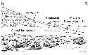 . The Ricardo Formation is a terrestrial succession, about 7,000' thick, of sandstone, siltstone, claystone, and conglomerate, with interbedded volcanic flows and tuffs, much of it highly colored and typically weathered into badland topography. Petrified wood is common in places; other, but rarer, fossils are remains of horses, camels, mastadons, rhinos, antelope, and Saber-toothcats (Sharp, 1976). . The Ricardo Formation is a terrestrial succession, about 7,000' thick, of sandstone, siltstone, claystone, and conglomerate, with interbedded volcanic flows and tuffs, much of it highly colored and typically weathered into badland topography. Petrified wood is common in places; other, but rarer, fossils are remains of horses, camels, mastadons, rhinos, antelope, and Saber-toothcats (Sharp, 1976). |
| | In the exposure across the flat lying before us, north dipping upper Ricardo beds, overlain unconformably by Pleistocene sand and gravel, are faulted against the "basement" rocks of the El Paso Mountains along the El Paso fault. We will later encounter lower Ricardo Formation bed lying above the "basement" rocks, demonstrating that the El Paso fault has experienced considerable dipslip as well as left-lateral strike slip displacement. |
| | Return to vehicle and proceed north. |