 , seven of which are geological.
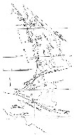
The first day will be devoted to the geology and some few historical items enroute to Big Pine and Camp Inyo. Much of what we see will be through car windows, while travelling at some speed, so it will be essential (unless you are sleeping) to keep a watchful eye on your odometer and to make frequent references to the California Geologic Map Sheets supplied you-Los Angeles, Bakersfield, Trona, Death Valley, Fresno, and Mariposa. On this first day, we will make only eight (8) stops (Fig. l)
, seven of which are geological.
| 0.0 (0.0) | Depart from Earth and Space Sciences loading dock. Turn right onto Circle Drive East, continue on Circle Drive South to Gayley. Turn right and proceed north to Montana and west to Sepulveda Blvd. Turn right and proceed north to Moraga Drive and join San Diego Freeway. |
| After joining the Freeway, the exposures immediately on the left are conglomerates and arkosic sandstones of both Cretaceous and Miocene ages in fault contact. The Miocene beds lie unconformably (although not discernable from passing cars) on the Jurassic Santa Monica Formation which we will pass through from this point to just south of Sepulveda Pass. The Santa Monica Formation is a very sparsely fossiliferous, dull grey succession of argillite and greywacke. To the east in the Santa Monica Mountains, it is intruded by the later Mesozoic Nichols Canyon granodiorite. Both, at various places in the range, are unconformably overlain by Cretaceous conglomerate or Middle Miocene Topanga sandstone or Upper Miocene Modelo Formation. | |
| 6.3 (6.3) | Crest of Sepulveda Pass. We have now passed into the Modelo Formation exposures, now largely grass covered. As we proceed down the north slope of the Santa Monicas toward the San Fernando Valley, some exposures of Modelo sandstone can be seen on the right. |
| The San Fernando Valley, which we will traverse over the next 10 miles is a broad synclinal trough, bounded on the north by a complex of high angle reverse faults which mark the south boundary of the San Gabriel Mountains. The San Fernando Valley contains between 1,000 and 1,500 feet of alluvial sand and gravel above many thousands of feet of largely middle Tertiary marine sedimentary rocks. | |
| 10.8 (17.1) | Here we enter the Mission Hills, exposing steeply tilted upper Miocene marine shales and early-late Pliocene sands and shales. |
| 3.3 (20.4) | At this point we cross the very complex southern margin of the San Gabriel Mountains, marked by the Foothill Fault zone and the Santa Susana thrust system, the general local of the 6.4 1971 San Fernando earthquake. From here to the next summit, about 3 miles, the large roadcuts expose complexly faulted, coarse conglomerates and cross bedded sandstones of the Pliocene Pico Formation. |
| Ahead, take right onto Antelope Valley Freeway (Hwy 14). | |
| 3.2 (23.6) | First summit. Proceeding down the grade beyond the summit, the horizontal beds of sandstone and conglomerate are Pleistocene Saugus Formation. |
| 0.9 (24.5) | Placerita Canyon, the site of the first placer gold discovery in southern California in 1842. |
| 1.0 (25.5) | Placerita oil field, discovered in 1948, on left. Beyond the oil field, and before we reach the next summit, we cross the San Gabriel fault (see Los Angeles map sheet), a major right-lateral fault closely related to the San Andreas fault. It is marked here by only a small change in the amount of dip in the Pleistocene beds along the highway. |
| 1.0 (26.5) | Summit. Pleistocene beds continue down the slope to the Santa Clara Valley, though they are less well exposed. |
| 2.4 (28.9) | Santa Clara River crossing. |
| 1.6 (30.5) | Sand Canyon Road. Angular unconformity between tilted late Miocene terrestrial Mint Canyon Formation and horizontal Pleistocene gravels on both sides of highway. We are now in the area of the Soledad Basin, a terrestrial Tertiary basin which derived a major part of its sedimentary debris from the ancestral San Gabriel Mountains to the south. About 25,000 feet of land-laid conglomerate and sandstone is known to have accumulated. For the next several miles we pass through exposures of tilted Mint Canyon beds. |
| 2.7 (33.2) | On left, a buttress unconformity of Pleistocene gravels against Mint Canyon. |
| 0.5 (33.7) | Pleistocene terrace gravels on left. In this vicinity, and especially at the mouth of Soledad Canyon on the right, we can see some of the Precambrian crystalline rocks of the San Gabriel Mountains. The nearly white exposures are of anorthosite, a plagioclase rich variety of gabbro which is intrusive into the gneisses of the San Gabriel complex. |
| 0.3 (34.5) | More west-tilted Mint Canyon or Tick Canyon beds. Tick Canyon formation underlies the Mint Canyon. |
| 2.3 (36.8) | Good exposure of the basal conglomerate of the Miocene terrestrial succession on both sides of the road. |
| 0.6 (37.4) | Just beyond the Agua Dulce turn-off, on the left side of the road is exposure of the unconformity between the basal conglomerate and the older (Oligocene) red beds of the Vasquez Formation. We soon pass through excellent exposures of typical coarse conglomerates of the Vasquez. About 1.5 miles beyond the unconformity, on left is a view of Vasquez Rocks at the County Park. |
| 2.0 (39.4) | Exposure of Vasquez volcanics, part of some 4,500 feet of basaltic flows in the lower part of the Vasquez Formation. |
| 3.2 (42.6) | Escondido Summit. |
| 3.2 (45.8) | Crown Valley Road exit. |
| 3.9 (49.7) | Soledad Canyon exit. |
| 0.5 (50.2) | Exposure of Lowe granodiorite, approximately 200 m.y. Beyond this large roadcut, the Angeles Forest road enters from the right. Stay on Highway 14. |
| 2.4 (52.6) | At this point, we pass through roadcuts in five ridges. The first, third and fourth cuts expose volcanic lavas and agglomerates of Oligocene age. The second cut exposes mixed fanglomerates and agglomerates of probable Oligocene age, and the last cut consists of Precambrian crystalline rocks. |
| 1.8 (54.4) | STOP 1, at Lamont Odet Vista Point. |